01External perimeter of a core facility
Approx. 5 kmSingle-site perimeter
Array nodes and EO/IR confirmation create a safe-offset awareness layer around a single assessed site.
PERIMETER REF / 01 NEW ARKACOUSTIC DETECTIONARC / PERIMETER
ARRAY NETWORK SOLUTION / 01
New Ark microphone-array networking is built around passive acoustic sensing and safe-offset, external-perimeter deployment. It can be designed from a local perimeter at approximately 5 km through multi-site, multi-region coordination at a scale of several thousand kilometres. Network scale is not single-node detection range; actual capability must be confirmed by site conditions, node configuration, and project validation.
Where radar cannot see, where radar cannot go, in the 20–150 m low-altitude band, even for fibre-optic UAVs with no RF signature — New Ark's passive acoustics hear, locate and report before intrusion, while you keep sovereignty over deployment and evolution.
INTEGRATED DEFENSE FILES / 01A
Prepared for project teams, this integrated-defense briefing covers system architecture, layered perimeters, integration conditions, and project-validation references. Choose the PDF for direct reading or the editable PPTX for internal review.
These files are for project communication and solution assessment. Configuration, performance, fit, and field arrangements remain subject to site authorisation, compliance review, and written project scope.
NETWORK SCALE / 02
Every network layer first defines its safe boundary, node spacing, communications interface, and maintenance responsibility before sensing and coordination capabilities are configured. The scale references below are solution architecture references—not a single-device performance commitment.
Array nodes and EO/IR confirmation create a safe-offset awareness layer around a single assessed site.
PERIMETER REF / 01Multiple confirmed sites consolidate events, status, and maintenance information through one project platform.
NODE REF / 02Supports tiered event assessment, interface management, and project-specific coordination across facilities.
REGION REF / 03Standardised interfaces link different regional networks while preserving site authorisation and data-responsibility boundaries.
FEDERATION REF / 04NETWORK SCALE, NOT SINGLE-NODE DETECTION RANGE
DEPLOYMENT SCHEMATIC / 03
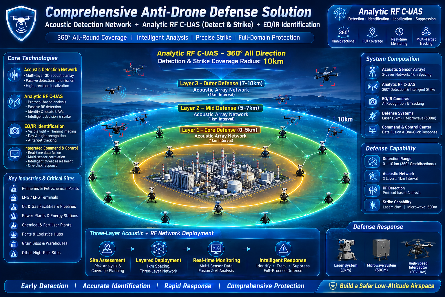
The array network should begin outside the core hazardous zone. Acoustic nodes, EO/IR confirmation, authorised RF interfaces, and the project platform can form layered coordination once installation conditions, communications boundaries, and ownership are defined.
SYSTEM PATH / 04
Passive acoustic arrays form the initial sensing layer; EO/IR supports identification and tracking confirmation; RF, radar, and the project platform connect through compliant interfaces. Authorised response capability is considered only after site authorisation, compliance review, and written project planning.
Acquires acoustic information from assessed external-perimeter nodes to form a continuous spatial-awareness reference.
Supports target identification, confirmation, and tracking within defined fields of view and mounting conditions.
Connects compliant RF or radar information sources as needed for a complementary sensing layer.
Coordinates multi-node and multi-region information under defined data permissions, alert rules, and interface responsibility.
ACOUSTIC TECHNICAL TEAM / PEOPLE & ENGINEERING
The core technical team brings more than 40 years of research experience in acoustic arrays and signal processing, while the engineering team averages more than 20 years in the field. Their work spans array design, algorithm optimisation, engineering deployment, and industrial-environment fit as a technical foundation for project-level sensing and validation discussion.
Chief acoustic scientist industry experience
Acoustic R&D engineering team experience
Research, prototype & engineering collaboration
Team credentials are company information provided by New Ark. Product configuration, site fit, validation scope, and project outcomes remain subject to field conditions, engineering review, compliance requirements, and written project documents.
 FIBER-OPTIC / PASSIVE SENSING REFERENCE
FIBER-OPTIC SCENARIO / 05
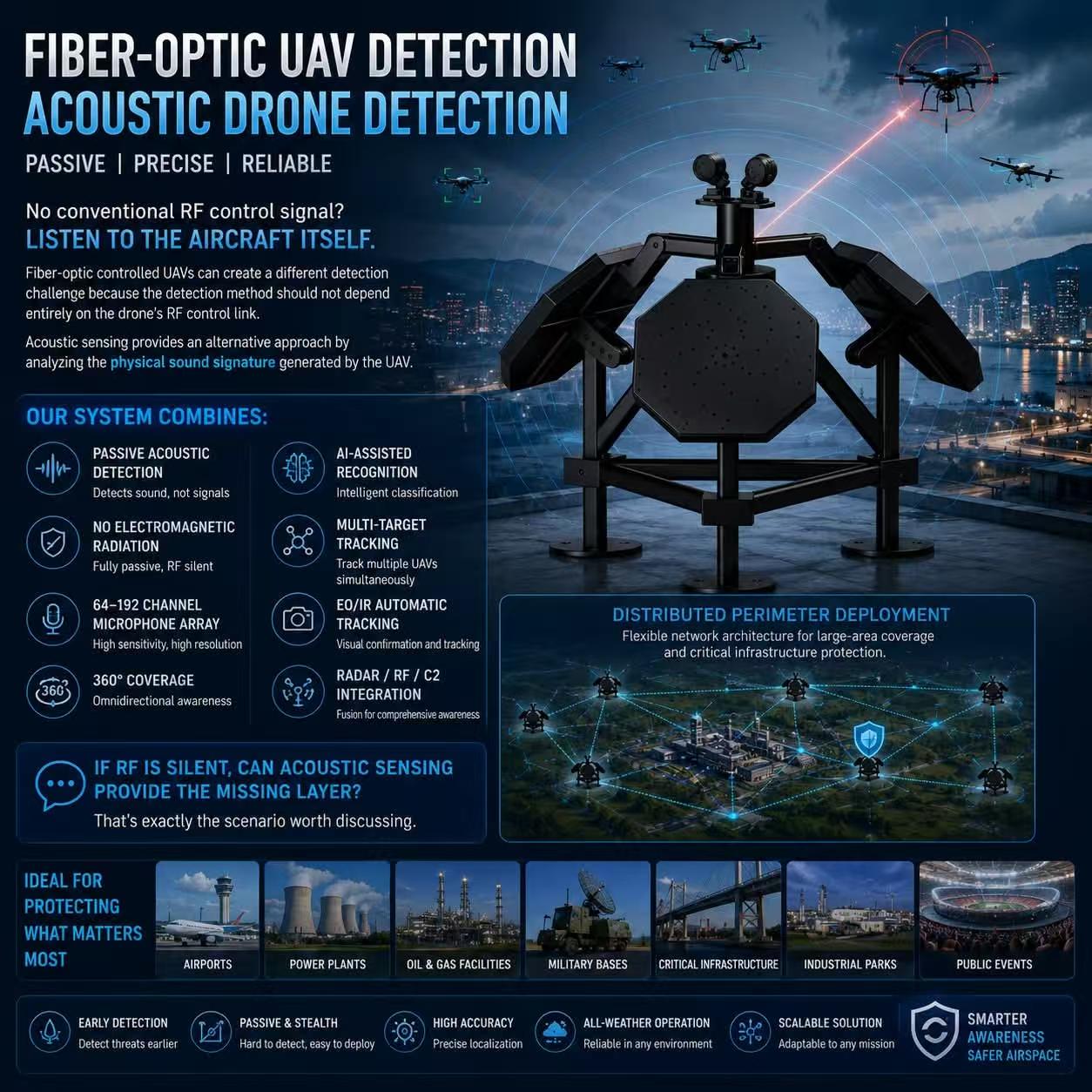
For scenarios such as fibre-optic controlled or low-altitude flight where conventional RF visibility may be reduced, acoustic sensing can provide a complementary information layer within a multi-sensor architecture. It does not replace site assessment; where project conditions allow, it provides a physical acoustic reference that can be reviewed.
FIRST DEFENCE REFERENCE / 05A
For authorised critical-infrastructure and high-security sites, fixed outer-perimeter nodes can form a 360° omnidirectional passive-detection and protocol-analysis complement outside the acoustic-array network. Once the safe boundary, spectrum permissions, and electromagnetic-compatibility review are complete, a project may further assess controlled precision-RF-response interfaces for remote-control and video-link UAV scenarios; actual fit, safeguards, and authority of use must be confirmed through field validation.
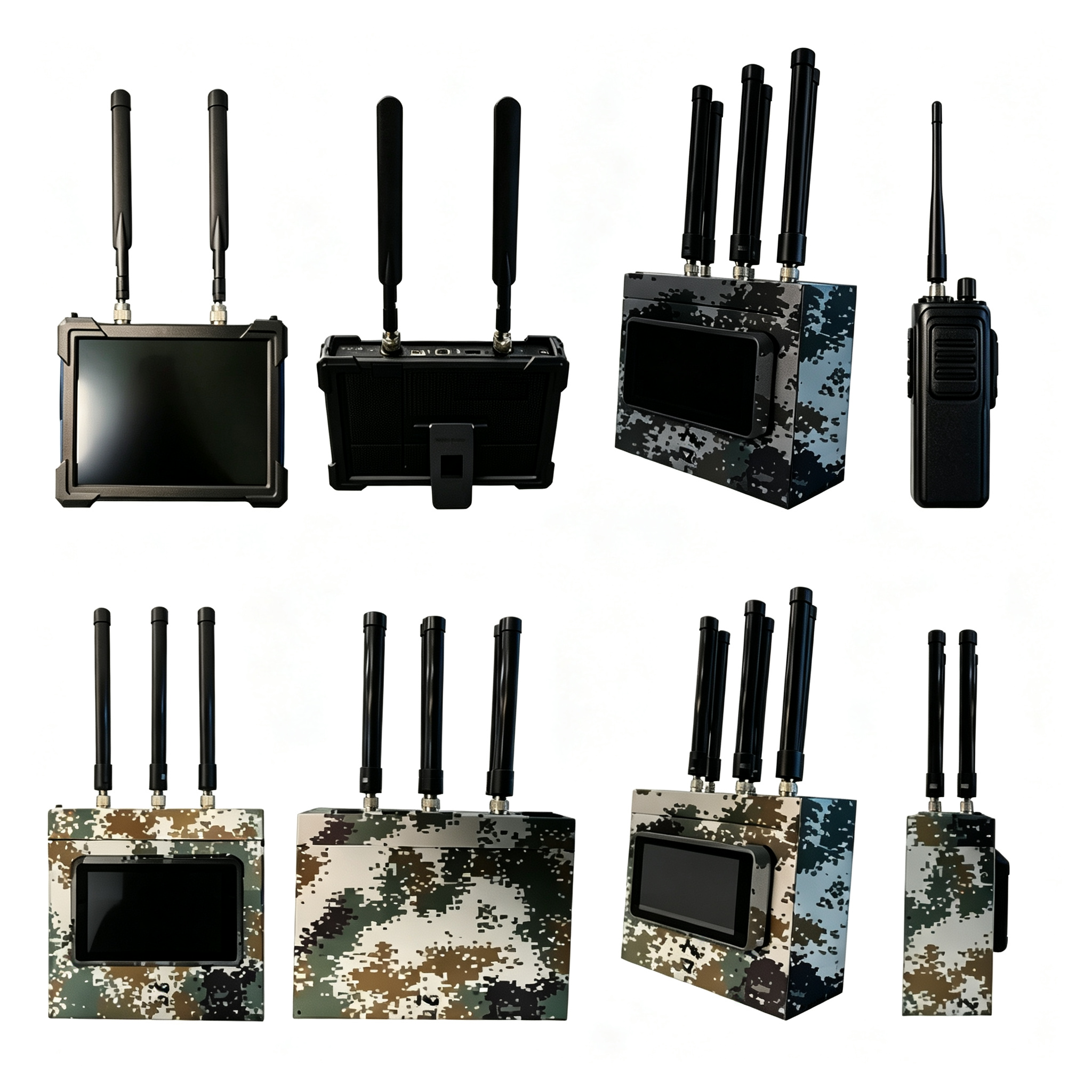
System-level reference for an approximately 20 km diameter outer protection area.
Defined jointly by assessed fixed nodes and the site layout; not a single-node performance promise.
Collects authorised RF and multi-sensor inputs in a monitoring framework without active transmission.
Project-specific protocol-analysis and RF-monitoring configuration range.
Applicability must be confirmed against target profiles, protocols, firmware, and site characteristics.
Node location follows compliant siting, fields of view, power, and communications conditions.
Any precision RF-response or interference assessment for remote-control and video-link UAV scenarios remains subject to applicable law, spectrum permissions, aviation and communications-protection requirements, on-site electromagnetic-compatibility testing, and written project authorisation. The design must treat protection of confirmed civilian communications, satellite navigation, Wi‑Fi, and public mobile services as a governing condition; conformance must be confirmed through site assessment and validation.
APPLICABLE DEPLOYMENT CONTEXTS / 05B
The contexts below are representative starting points for project-fit discussions only. Each application requires independent assessment against local regulation, site authorisation, communications environment, and operational responsibility.
Airports, inland oil fields, refineries, oil-and-gas storage, LNG and chemical parks, large hydropower stations, dams, and inland water-control hubs.
PERIMETER CONTEXT / 01Ocean cargo ports, container terminals, large open-pit mines, rare-mineral operations, and other confirmed industrial perimeters.
PERIMETER CONTEXT / 02Prisons, high-security detention centres, important closed public facilities, and government-security areas approved by competent authorities.
PERIMETER CONTEXT / 03Authorised border-control units, border posts and checkpoints, defence facilities, temporary operations, large outdoor events, and controlled exercise sites.
PERIMETER CONTEXT / 04PUBLIC CRITICAL-PERIMETER EVENT REFERENCES / SOURCE-ATTRIBUTED NEWS
These source-attributed refinery and airport videos are perimeter-event references. They prompt project teams to consider safe-offset sensing, corroboration, alert coordination, civil-aviation and public-communications protection, and human-authorised review before an event. They do not demonstrate a particular system result or make an operating, response, or performance claim.
LOCALLY HOSTED REFERENCE VIDEO · Owner-provided source
This owner-provided video supports a discussion of event context at refinery and high-risk industrial perimeters. It prompts teams to define external sensing, corroboration, alert escalation, personnel coordination, and written-authorisation boundaries before an event; it does not independently confirm incident detail or cause.
Source: owner-provided video file · incident details are not independently verified on this page
LOCALLY HOSTED REFERENCE VIDEO · TTV LIVE
This public news source concerns a reported drone entry into an airport and related operational context. It supports discussion of sensing, alert escalation, and field coordination defined before an event.
View original sourceYOUTUBE · Global News Taiwan
This public news source concerns a reported German-airport drone event. Political attribution in the source title remains the publisher's assertion and is not independently confirmed here; this page retains it only as a source record for perimeter-risk discussion.
View original sourceSource-attribution notice: New Ark was not involved in the referenced events and does not independently verify incident details, timing, operational impact, damage, cause, response arrangements, or political attribution in the videos. This page retains them only as source records for project-level perimeter-risk discussion.
NEXT-GENERATION FPV RESEARCH / 06A
This R&D reference considers early information acquisition, human authorisation, and automated alert coordination in high-speed FPV scenarios. Beginning with fixed outer-perimeter nodes, it combines site safety boundaries, sensing confirmation, and escalation paths to provide a reviewable validation framework—not an operational response plan.
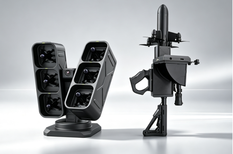
A first fixed outer perimeter defines the high-priority sensing and confirmation path.
A project-validation reference for high-speed target risk assessment, not a public operating-performance promise.
Any controlled response remains subject to human authorisation under written permissions and site safety procedures.
Supports tiered alerts, information aggregation, and defined escalation only; it never replaces accountable field judgement.
PROJECT RISK ANALYSIS / 06B
The performance-analysis image below was supplied for the project and is placed within the coordinated-awareness and human-authorisation assessment framework beginning at the 10 km first-layer perimeter. Its figures are not a public performance, interception-result, or suitability commitment. Actual assessment is determined jointly by site boundaries, target characteristics, environmental conditions, sensor corroboration, competent-authority requirements, and written validation.
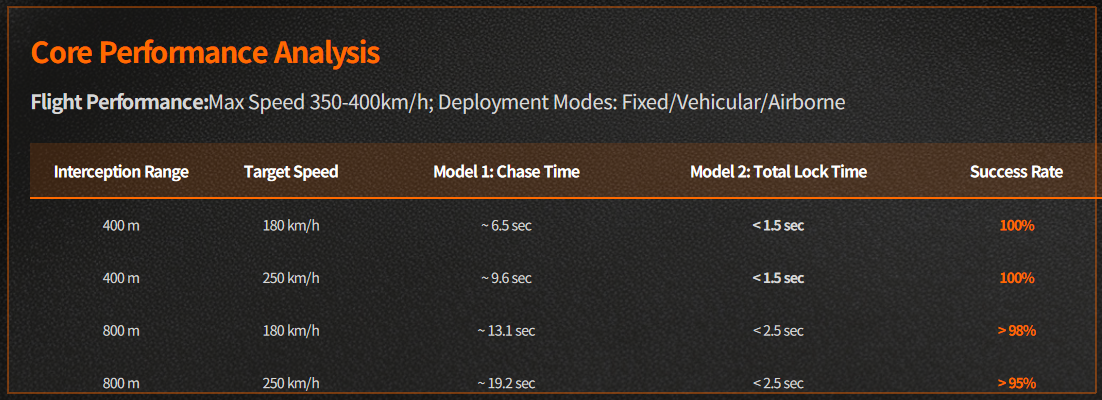
This module discusses only an awareness, confirmation, automated-alerting, and human-authorisation framework for high-speed risk. Any further capability, platform use, field demonstration, or response arrangement remains subject to applicable law, site permissions, airspace and safety rules, personnel qualifications, and written project validation; this public page does not provide interception, response execution, or control procedure.
SECONDARY PERIMETER LAYER / 08
A vehicle-mounted mobile platform within an assessed 7–8 km outer-layer reference can serve as a supplementary project configuration in a layered perimeter architecture. It assumes site authorisation, road conditions, spectrum permissions, and a written operating plan, allowing project teams to discuss controlled-response interfaces for fibre-optic UAS scenarios, high-density multi-target events, and temporary operating areas.
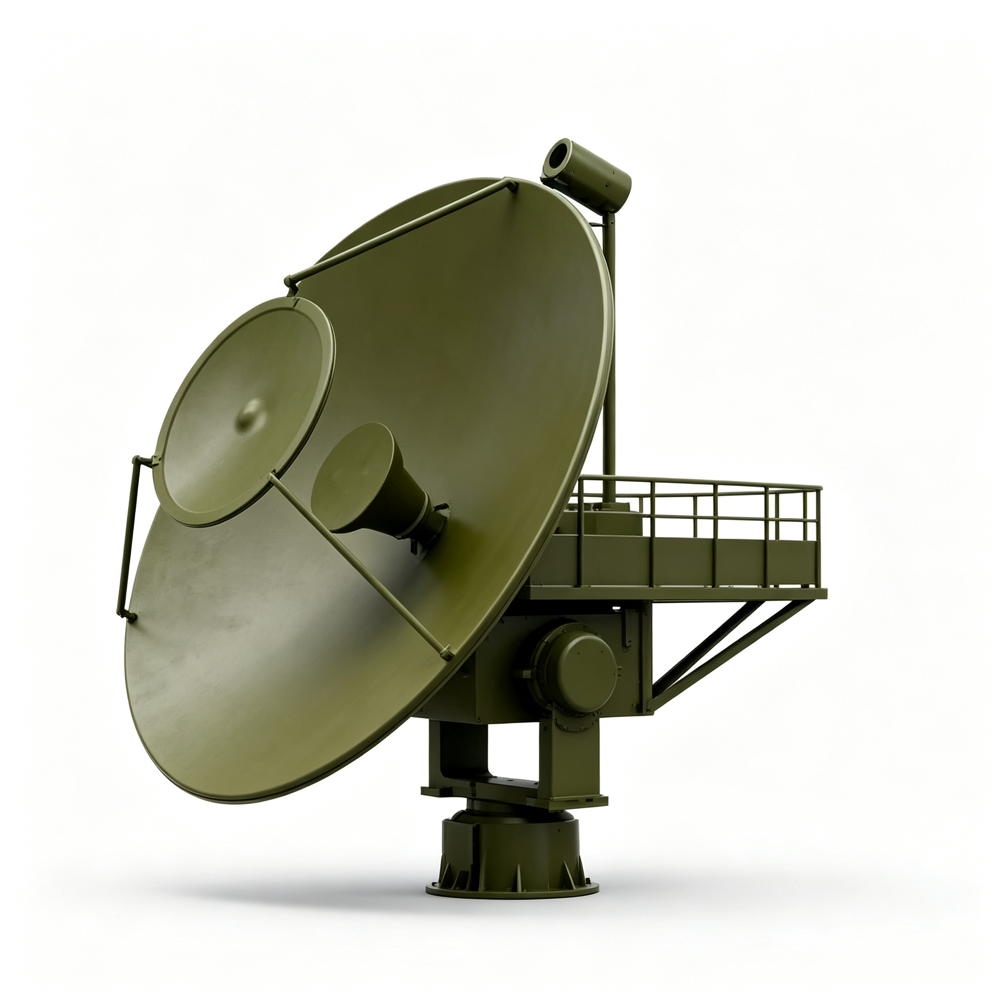
Outer coordination position follows site boundary, road conditions, and the layered sensing design.
Project assessment and coordination reference for fibre-optic controlled or high-density multi-target scenarios.
Reference only for an authorised vehicle-mounted microwave response configuration; on-site conditions must be confirmed.
Dispatched according to temporary operating areas, project boundaries, personnel procedures, and site permission.
Platform availability, applicable target profiles, response modes, and safety procedures must be confirmed together by competent authorities, site authorisation, spectrum permissions, aviation and communications-protection requirements, personnel qualifications, and field validation. This public page shows only a project-assessment reference; it does not provide response execution, control parameters, or operating procedure.
SECOND-LAYER DEPLOYMENT CONTEXT / 09
The contexts below are for project-fit discussion. Every project should be defined only after local regulation, written authorisation, on-site safety procedure, and operational responsibility are established.
Airports, inland oil fields, refineries, oil-and-gas storage, LNG and chemical parks, major hydropower stations, dams, inland water-control hubs, and large open-pit mining areas.
VALIDATION CONTEXT / 01Ocean cargo ports, container terminals, rare-mineral operations, prisons, high-security detention centres, and approved closed public-security areas.
VALIDATION CONTEXT / 02Border-control units, border posts, checkpoints, defence facilities, defence-industry areas, and controlled exercise sites, subject to applicable competent-authority requirements.
VALIDATION CONTEXT / 03Authorised vehicle deployments, outdoor major events, temporary assembly operations, and counter-terrorism exercise scenarios, each requiring a separate coordination and risk-assessment process.
VALIDATION CONTEXT / 04THIRD PERIMETER LAYER / 10
A vehicle-mounted laser platform within an assessed 5–6 km outer-layer reference can serve as a project-specific complement in a multi-layer perimeter architecture. It is governed by site authorisation, operating permissions, road conditions, airspace safety procedures, and a written validation plan, allowing teams to discuss controlled fit for fixed-wing UAS scenarios, complex perimeters, and temporary operating areas.
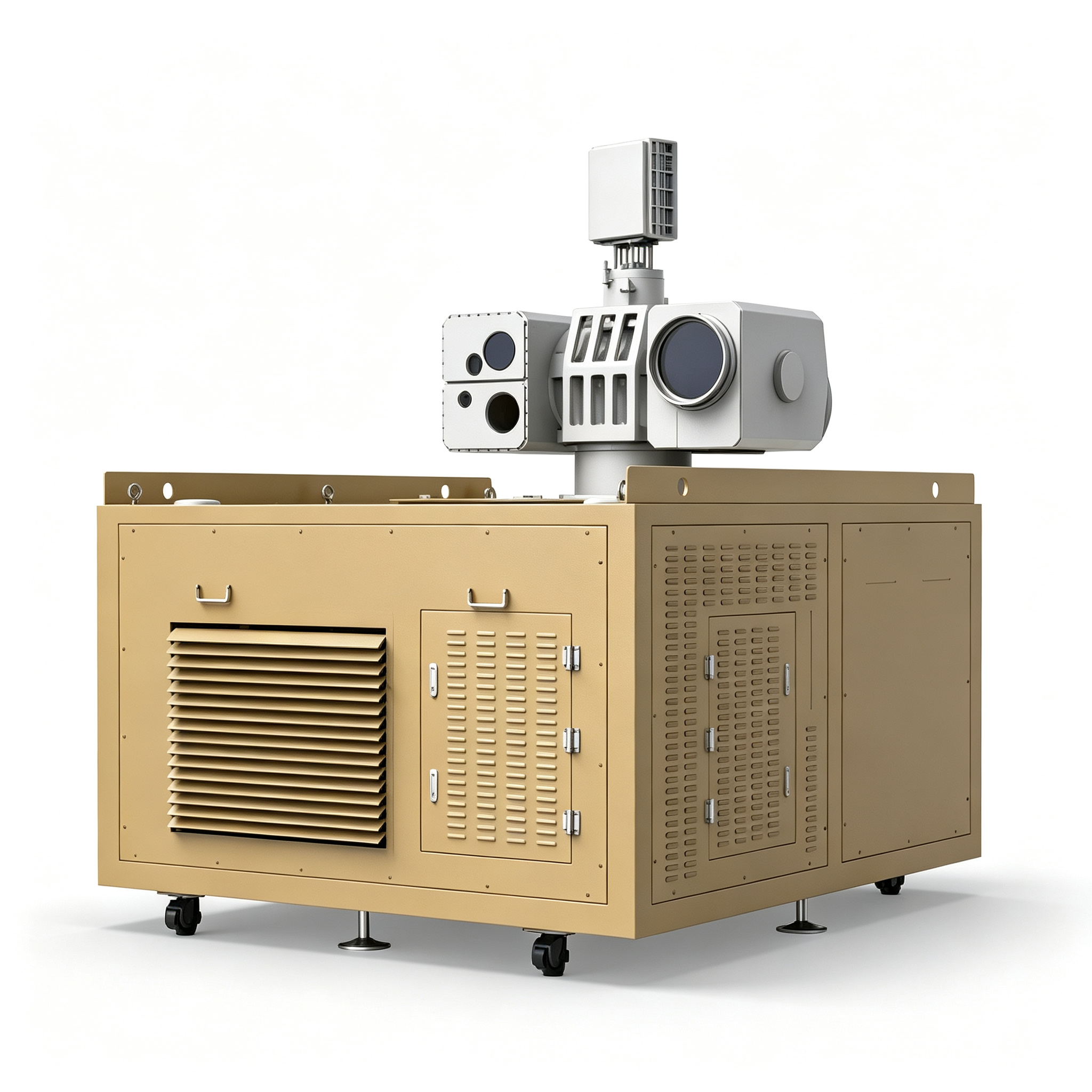
Coordination position follows safe boundary, fields of view, road conditions, and the multi-layer architecture.
Project-fit and coordinated-validation reference for authorised fixed-wing UAS scenarios.
Reference only for an authorised vehicle-mounted laser response configuration; field validation confirms actual fit.
Dispatched around site permissions, personnel procedure, temporary task boundaries, and safety separation.
Platform availability, applicable target profiles, operating conditions, and safety procedures must be confirmed together by competent authorities, site authorisation, airspace and safety requirements, personnel qualifications, environmental conditions, and written project validation. This public page is a project-assessment reference only; it does not provide response execution, control parameters, or operating procedure.
THIRD-LAYER DEPLOYMENT CONTEXT / 11
The contexts below are for project-fit discussion. Each project should be defined only after local regulation, written authorisation, site safety procedure, and operational responsibility are established.
Airports, inland oil fields, refineries, oil-and-gas storage, LNG and chemical parks, major hydropower stations, dams, inland water-control hubs, and large open-pit mining areas.
VALIDATION CONTEXT / 01Ocean cargo ports, container terminals, rare-mineral operations, prisons, high-security detention centres, and approved closed public-security areas.
VALIDATION CONTEXT / 02Border-control units, border posts, checkpoints, defence facilities, defence stores, defence-industry areas, and controlled exercise sites, subject to applicable competent-authority requirements.
VALIDATION CONTEXT / 03Authorised vehicle deployments, outdoor major events, temporary assembly operations, and counter-terrorism exercise scenarios, each requiring a separate coordination and risk-assessment process.
VALIDATION CONTEXT / 04SOLUTION FAQ / 12
These answers explain the public ARC-PERIMETER solution architecture. Final deployment, interface definition, equipment fit, and compliance conditions remain subject to qualified project teams and actual site conditions.
DEFINE THE NETWORK BOUNDARY / 06
Bring the site extent, critical facilities, intended coordination scale, and mounting conditions into a validation-led project conversation.